PALM TREE PRODUCTIONS
back to Albania site back to hikes and climbs back to Locations and Travel
To Klos via Shengjergj and Guri Bardhe![]()
Summary: An enormously enjoyable drive with considerable elevation gain and losses (almost 2000 Meter), starting at Dajti Mountain near Tirana. Nothing for those with a fear of heights! Not many people seem to know whether this road still exists. The trail takes a new dirt road to Shengjergj. From there, it climbs - via Shenmarie - to the dizzying heights of Mali me Gropa (you may climb Mali me Gropa from here - see separate trail). The trails cuts across the steep side of the mountain, and eventually takes the turn to Klos (waypoint D). Most of the roads are occasionally travelled, though a short stretch followng the turn off to Klos has very deep ruts, requires caution and might be impossible when wet. The road climbs further to its highest point (about 1520 Meter) before descending gradually to Guri Bardhe and, eventually, Klos.
| Maximum altitude: | 1487 meter |
| Minimum altitude: | 290 meter |
| Cumulative height: | 1949 meter |
| Cumulative length: | 61 kilometers |
| Difficulty | difficult |
| Time: | 4-6 hours |
| Date of this record | August 2011 |
| Download GPS info: | To Klos |
General location and approach: The trail starts at the Dajti Mountain, at the pass where there are some quarries. You reach the trail at waypoint A, on the asphalt road at the pass on Dajti Mountain. (see map below, and click ro enlarge). The described route follows waypoint C, B, D in that order, before continuing to Klos. The road from the pass continues straight ahead down the mountain - do not follow the asphalt road to the left (north), as this would be another option. From the pass, you have a good view of the first half of the trail - down to Shengjergj and up to Mali me Gropa.
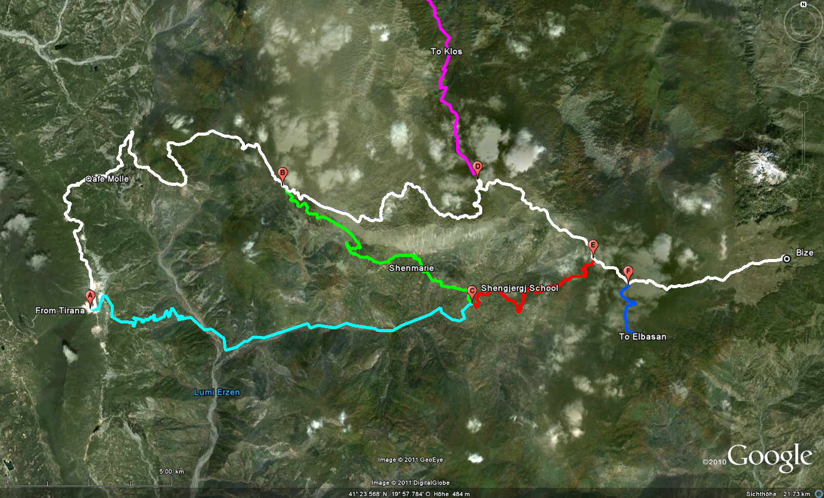
Other Options: From waypoint A you can turn left and follow the white trail (badly bropen asphalt), cross Qafe Molle, pass point B and reach D.
You may also travel from A to C (Shengjergj) and continue the red trail to waypoint E, where you turn left to reach waypoint D. The red trail has some short difficult spots (erosion), which however were manageable in summer 2011.
The trailhead for climbing Mali me Grop is near waypoint B, on the white trail. The trailhead for climbing Mali i Snojt is near Bize, the end of the white trail
Other Information: Plan to spend the entire day. Though always on roads, we rated the trail difficult on the grounds of a few hundred meters difficult terrain, the overall length of the experience, and the fact that you may find yourself alone for the almost the entire day. The trail is impossible as long as there is a chance of snow lingering in the shadows.
GPS and trailmaps: The map and trailinformation is generated by www.wikiloc.org, based on GPS information collected from the actual hike. Waypoints can be downloaded to a GPS device from Wikiloc. If necessary, use GPSBabel to convert GPS data to different formats. For more hike descriptions by Palmtreetreeproduction, browse this website or visit Wikiloc and search for "Palmtreeproduction". You may also find nearby trails from other authors.
Google Earth: You may also view the trail in 3D by clicking "view in Google Earth" when on Wikiloc. You need to have Google Earth installed on your computer.
Images: Click the
![]() button at the end of the page to view the slides in full screen
button at the end of the page to view the slides in full screen