PALM TREE PRODUCTIONS
back to Albania site back to hikes and climbs back to Locations and Travel
Ultra: Papingut from Permet![]()
Summary: Mali i Nemercke is one of the Albanian ultra-prominent mountains, meaning that - theoretically - you have to descend more than 1500 meter in order to climb a mountain that is higher. In other words, its prominence is more than 1500 meter.
The designation of being an Ultra does not necessarily mean that you have to climb 1500 meter or more to reach its summit. There could be roads leading high up. But there is something magical about going it all the way by foot.
In the case of Nemercke Mountain (with its summit Papingut, or Maja e Dritës) it is an obvious thing to do. The western slopes of the Nemercke ridge are somewhat hidden in the Zagoria valley, and the hike is not very difficult. But Nemercke's eastern face drops almost vertically into the Vjosa valley. While the summit of Papingut is measured at 2485 meter, the Vjosa runs at 200 meter altitude right below its summit and the amphitheater. It is probably the most alpine and most dramatic view of a mountain to be had in Albania outside the Albanian Alps. With the unavoidable ups and downs of a long hike, this means that one has to climb more than 2300 meter from Gjinkar near Permet in order to reach the summit.
Such elevation gain requires an overnight hike, and we decided to make use of a mule to carry our supplies. Our camp was planned at about 1900 meter, requiring an ascent of 1650 meter on the first day. On the summit day, one still needs to climb close to 700 meter, and about 2350 meter down. Total distance on the second day is about 18.5 kilometer.
The steepest section of the trail is through forest, leading from some grazing areas at 850 meter to about 1550 meter. From here, the gradient is more comfortable, leading into a gap in the Nemercke ridge. This is where we made camp. There is no water here, but there was snow in May.
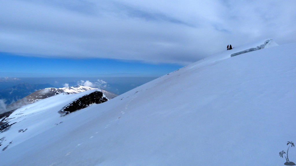
Once the summit ridge is reached, the gradient is even more easy, though one should beware of the steep drops on the eastern side. In early May, the ridge was still covered in snow, with enormous cornices on the eastern face. Do not be tempted to walk to the edge; keep a respectful distance, even if it limits the views directly down the vertical walls.
Depending on snow conditions, there might be some tricky parts, especially in the morning when the snow is still frozen. If the trip is planned earlier than May, an ice axe would come in handy. In summer, the trail should be more obvious with no real difficulty. Overall, for a trip in May, we rate the trail as difficult, mainly on account of its length, and required orientation skills should the weather turn bad. As long as snow conditions are good and visibility is fine, any difficulty can be avoided.
| Maximum altitude: | 2485 meter |
| Minimum altitude: | 268 meter |
| Cumulative height: | 2309 meter |
| Cumulative length: | 13.8 kilometer one way |
| Difficulty | difficult |
| Time: | 2 days, overnight |
| Date of this record | May 2014 |
| Download GPS info: | Papingut from Permet |
To the trailhead: Reach Gjinkar village by leaving Permet in the direction of Greece, or Korca. In Badelonje (at a Café called Nemercke), cross the Vjosa River on a steel bridge. Stay on the riverside until a sharp turn to the right leads you to Gjinkar.
Gjinkar is part of Petran commune. Note that the bridge from Petran viallge to Gjinkar is not suitable for motor vehicles. If you have to use public transport, drive to Petran, cross the footbridge and walk from there.
Other Information: We were ably assisted by Aleks Dhimitri from Gjinkar village, who cheerfully accompanied us. Our overnight belongings (for 4 persons plus for Aleks) were no problem for his mule Russ. We even were treated to home cooked chicken, byrek, bread and fruit. While Russ waited patiently at our camp, Aleks went with us to the summit of Papingut. He likes to share (in Albanian language) his excellent knowledge of the area, including fauna and flora. We highly recommend to get in touch for this or similar tours; make sure someone in your party speaks Albanian. His phone numbers are 0696640365 and 0682254717.
Very helpful is also the mayor of the commune Petran, Mr. Niko Shupuli, 0684020717. He speaks some English and can help with referrals. Petran commune office is just outside Permet, not in Petran village.


GPS and trailmaps: The map and
trailinformation is generated by
![]() , based
on GPS information collected from the actual hike. Waypoints
can be downloaded to a GPS device from Wikiloc. If necessary, use
GPSBabel to
convert GPS data to different formats. For more
hike descriptions by Palmtreetreeproduction, browse this
website or visit Wikiloc
and search for "Palmtreeproduction". You may also find
nearby trails from other authors.
, based
on GPS information collected from the actual hike. Waypoints
can be downloaded to a GPS device from Wikiloc. If necessary, use
GPSBabel to
convert GPS data to different formats. For more
hike descriptions by Palmtreetreeproduction, browse this
website or visit Wikiloc
and search for "Palmtreeproduction". You may also find
nearby trails from other authors.
Google Earth: You may also view the trail in 3D when viewing it in Google Earth, which you need to have installed on your computer. The 3D perspective allows a good preview of gradients, steepness, possible views and is generally helpful when planning a trip.